Pageviews in last month
Sunday, 28 August 2011
Sun, Aug 28, 2011 - 7.20 mi [Cycling] Newcastle to Jarrow
Sun, Aug 28, 2011 - 7.20 mi [Cycling]
7.20 mi in 00:27:58 hours at 15.45 mi/h on Pinnacle Hybrid. [Cycling] Very fast ride home from Newcastle - wind less gusty but still a bit tricky conditions.
Sun, Aug 28, 2011 - 8.93 mi Jarrow to Newcastle
Sun, Aug 28, 2011 - 8.93 mi [Cycling]
8.93 mi in 00:44:42 hours at 11.99 mi/h on Pinnacle Hybrid. [Cycling] Cycle up to the Spittal for a pree match drink then on to St James to see another good Toon performance and a well deserved win over Fulham. Very tough going into a strong headwind which I would guess was gusting up to 40 or 50 mph - Tricky Cycling
Day 11 : Wed, Aug 24, 2011 - 74.90 mi [Cycling] Finsterwalde to Berlin
Day 11 : Finsterwalde to Berlin
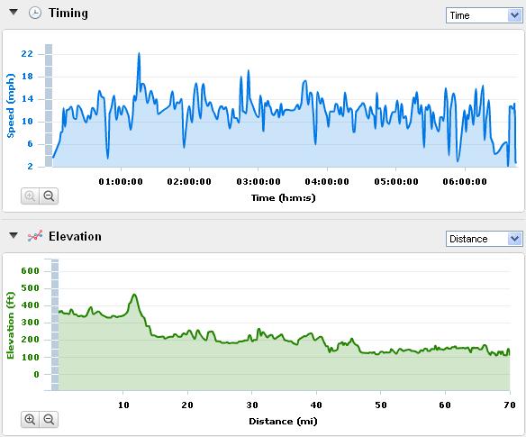
Distance = 70.02 Miles
Time = 05:50:29 hrs
Ave Speed = 11.99 mph
Elevation = 1567 ft
Calories = 3508 Calories
Max Speed = 22.3 mph
Max Height = 467 ft
Min Height = 112 ft
Tour Stats
Distance = 1005.85 miles
Time = 84:01:07 hrs
Ave Speed = 11.97 mph
Total Elevation = 33692 ft
Total Calories = 52431
I had 70 miles to complete to reach Berlin and I would also be completing 1000 miles for the tour. I had thoroughly enjoyed my extra day and I was really glad I stopped in Finsterwalde even if it did mean 1 less day in berlin.
The Town is called the Singing Town and it has a reputation for being really friendly and my Hotel was really good - I enjoyed a lovely meal in the garden and a few beers to celebrate - It's hard to put into words but tonight I knew I was going to make Berlin ... and that is the first time I could honestly say that !
I set off North along another Strassen Schaden (Uneven road) which was barriered off - fortunately it did go through and before long I was on the Bundestrasse 96 which was a straight road North to Berlin.The road was beautiful lined with large mature trees and I did have a laugh when I saw a sign showing a car crashing into a tree to presumably tell you not to drive into a tree !
The road lead to the first reasonably sized town which was Luckau and even though it was only 20 miles away I was pretty sore aand tired and started to wonder if I would make it to Berlin today after all - I bought some drinks at a garage and pressed on North.
I was now cycling through beautiful but quite thick forests and I passed through Zutzen, Baruth & Neuhof all of which were about 7 miles apart and separated by dead straight road on which the wagons were starting to build. Just after Neuhof a white van decided to overtake a Wagon heading towards me - Immediately I thought "This is going to be tight" so I braked and hopped my bike off the road onto the forest verge....
The van didn't make it back in in time & would have totalled me had I not seen it coming !!
The Wagon driver went mental and started blaring his horn at the van as the van tried to speed off from him into the distance - I suspect a chase was on :-)
I passed a monument to the war with two russian tanks sitting on plinths alongside the B96 road and stopped to take a picture. Shortly afterwards I was at Zossen which is pretty much the start of Berlin albeit 20 miles away. Another 7 Miles and I was crossing the Autobahn south of Berlin that is the Berliner Ring motorway.
I then picked my way via minor roads and cycle paths into the City centre and my route took me down Wilhelmstrasse and past Checkpoint Charlie from there I went straight through the non traffic section past the British Embassy which lead to Unter den Linden. A left turn and up to the top of the street and I was there 'THE BRANDENBURG GATES' - my symbolic journey's end.
I cycled under the gate and decided a photo is required. The place was crowded and I saw an Italian family on a tandem who had cycled to Berlin - they were being swamped and had almost a press corp surrounding them taking pictures. I wandered looking for someone who could speak English but the place was surprisingly devoid of anyone I could ask. The Italian celebrations continued ... I felt well pretty deflated having 2 minutes ago been on such a high - the tiredness and cold was starting to cut in - I continued to look - I asked some Koreans but they didn't seem to understand - eventually I found two Japanese lads who did take my picture - I muttered Paris, Prague, Berlin, Bicycle and pointed to my bike but I think the significance of my achievement didn't register - I was to celebrate my achievement in solitude.
I cycled back down Unter den Linden, down Wilhelmstrasse to Checkpoint Charlie where I turned left onto Zimmerstrasse where my Hotel for the next 2 nights was - As it turned out Zimmerstrasse is actually the route of the former Berlin wall and my Hotel was actually on a corner of the wall - the building itself forming the boundary with East Berlin
Route :
<
Photograph :
 |
| 10 Miles : Near Pahlsdorf these goats got really friendly and came across to me to let me take their photograph. |
 |
| 12 Miles : Don't you just love German Road Signs |
 |
| 12 Miles : A close up - this sign had me in stitches :-) |
 |
| 12 Miles : Oh No Disaster I should have heeded the warnings - I've gone & crashed my bike into a Tree Shame they didn't have a sign to warn me !!! |
 |
| 38 Miles : Just near Muckendorf still on the Bundestrasse 96 came across this monument with 2 soviet tanks on plinths by the roadside. |
 |
| 46 Miles : Just before Zossen on the outskirts of Berlin I stopped in the forest to take a closer look and as you can see it's pretty dense in there. |
 |
| 46 Miles : In the forest still - Looking Up & thise trees are high perfect to wrap in ribbon & hang hoops from ! |
 |
| 18 miles : This is the first sign for Berlin that I had seen that wasn't via a Motorway so I had to stop & take a picture - I was 3 miles south of Luckau & about 45 miles south of Berlin - It almost brought a smile to my face :-) |
 |
| 52 Miles : I reached the A10 which is the Berlinerring - The Berlin Ring Road - well it does bypass Berlin but it was still 18 miles south of the City Centre. |
 |
| 55 Miles : Double Take Och Aye I see it now - not quite in Scotland ! |
 |
| 70 Miles : Journey's End - 1007 Miles from the Eifel Tower to the Brandenburg Gates (via Prague !) |
 |
| Berlin : this is just behind the Reichstag on the River Spree |
 |
| Berlin : The Reichstag |
 |
| Berlin : I found Martin Luther just near the Tower at the Alexanderplatz |
 |
| Berlin : A close up of the dome on the Reichstag |
 |
| Berlin : The Memorial to the Murdered Jews of Europe also known as the Holocaust Memorialis a memorial in Berlin to the Jewish victims of the Holocaust, designed by architect Peter Eisenman and engineer Buro Happold. It consists of a 19,000 square metres (4.7 acres) site covered with 2,711 concrete slabs or "stelae", arranged in a grid pattern on a sloping field. The stelae are 2.38 m (7 ft 10 in) long, 0.95 m (3 ft 1 in) wide and vary in height from 0.2 to 4.8 m (8 in to 15 ft 9 in). According to Eisenman's project text, the stelae are designed to produce an uneasy, confusing atmosphere, and the whole sculpture aims to represent a supposedly ordered system that has lost touch with human reason. |
 |
| Berlin : A clock in Alexanderplatz which shows the time in every Time Zone in the world |
 |
| Berlin : A piece of the Berlin Wall outside the Checkpoint Charlie museum |
 |
| Berlin : Checkpoint Charlie |
 |
| Berlin : The Brandenburg Gates |
 |
| Berlin : A colourful wall on a building near the Alexanderplatz. |
 |
| Berlin : Berlin TV studios and 3 very famous world leaders :- George Bush, Helmut Cole & Mikael Gorbachev who were in power when the wall came down in 1989 |
 |
| Berlin : The Alexanderplatz looking towards the TV tower |
 |
| Berlin : The Ferneshturm from pretty much underneath it. It was built between 1965 - 1969 and at 368 metres is the tallest building in Germany. |
 |
| Berlin : An unorthodox view of the Fernsehturm taken from Karl Liebknecht-Strasse looking at St mary's church with the tower directly behind. |
Day 10 : Tue, Aug 23, 2011 - 57.22 mi [Cycling] Dresden to Finsterwalde
Day 10 : Dresden to Finsterwalde
 Day 10 Stats
Distance = 57.22
Time = 05:32:29 hrs
Ave Speed = 10.32 mph
Elevation = 1421 ft
Calories = 2450
Max Speed = 20.0 mph
Max Elevation = 707 ft
Min Elevation = 306 ft
Tour Stats
Distance = 935.83 Miles
Total Time = 78:10:38 hrs
Ave Speed = 11.07 mph
Total Elevation = 32125 fett
Total Calories = 48923
Day 10 :
Quite a slow start as I had not got the Internet key before I went out last night and the desk was closed when i returned so i had to book my Hotel in Finsterwalde and check my route in the Garmin before setting off.
Yesterday was my longest ride and my body was feeling the effects today - I had realised that I was incapable of doing the remaining 140 miles in 1 day so I had decided Finsterwalde was a good half way point.
Once sorted I cycled into town for a quick look around Dresden and to take a few photographs before setting off for the day. I was heading pretty much due North and as I left Dresden my poor sore body was not enjoying the first 5 miles which were pretty much all cobbles and between 4 to 8 miles I climbed another 400feet - Once I went under the E40 autobahn the I turned off main road I had been following and I picked up samller roads which were perfect for cycling.
I made steady progress if not fast and I reached the town of Barnsdorf which .. surprise surprise was cobbled.In the small village of Weissig am Rassutz I stopped as I passed a house with a garden that had been decorated with wood carvings - I think it was snow white and the seven dwarves that had been carved and were forming the garden fence.
At Tetten there was sign post saying Strassen Schaden and I wasn't sure if the road was open or not as half had been barriered off.- I cycled on and the road remained open & Ok but the landscape changed dramatically - the fields were suddenly barren and flat and white, there were no trees and the road was sitting on the landscape with a unnatural ditch between.
Then after a couple of mile I saw a high structure come into view on the horizon - It was industrial, It was massive. It was .... obviously chewing up the landscape and turning the earth into what looked like the moon.
When I reached the machine it was a very large metal framework with conveyors - it must have been 100fett high and 500 feet long.
Once past it the landscape quickly greened up and I was in no time at Licherfeld and a short ride down the road into Finsterwalde.
Route :
Photographs :
 |
| 1 Mile : I stopped on the bridge across the Elbe to photograph this wave and my bike ! |
 |
| 2 Miles : This is a small part of a wall which remained in the Old Town of Dresden after the bombing raids in 1945. |
 |
| 2 Miles : Another view of the section of wall that wasn't bombed in 1945. |
 |
| 2 Miles : Dresden Old Town |
 |
| 1 Miles : A fountain in Dresden near the Bridge over the Elbe |
 |
| 1 Mile : This is a gold statue which faces the bridge over the Elbe |
 |
| 2 miles : A large stone gothic figure carved into the wall guards two large doorways in the Old Town. |
 |
| 2 Miles ; I looked up and saw this view - a dome topped with a gold winged messenger watched over by two black carved figures. |
 |
| 2 Miles : A statue in the square of Martin Luther. |
 |
| 2 Miles : On top of an old building in Dresden - the inscription The Fatherland - To fuss and Honour. |
 |
| 2 Miles : A horse and Carriage in Dresden Old Town |
 |
| 2 miles : The massive Porcelain Wall in Dresden Old Town which was made by the famous Meissen Potters which is only about 10 miles west of Dresden. |
 |
| 27 Miles : A garden in Weissig am Raschutz with wooden carved figures |
 |
| 27 Miles : A closer inspection of the figures show that the they are in fact Snow White and the seven dwarves. |
 |
| 45 Miles : Just leaving Lauchhammer this sign warned the road may not be too level - shortly afterwards there was a barrier across half the road and I wondered if i was venturing down a dead End. |
 |
| 47 miles : The landscape began to change - the vegetation seemed to be dying and looking ahead I could see what looked like the Moon |
 |
| 49 Miles : I approached the enormous Orwellian looking machine that had obviously changed the countryside over which I had been cycling for the last 4 miles. |
 |
| 57 Miles : A pretty rooftop in the Town Square in Finsterwalde |
 |
| 57 Miles : Finsterwalde is called Die Sangsterstadt The Singers Town and this statue is in the town square The statue depicts the 3 singers from Town who won a national singing contest in the 1930s |
 |
| 57 Miles : The own Square in Finsterwalde |
 |
| 57 Miles : I wandered around town ans found this very large and very very odd, derelict looking clock tower. It almost looked sinister. |
 |
| 57 Miles : A better view of the clock tower ... but there wasn't a clock on this side of the tower |
 |
| 57 Miles : This is the Town Hall - the Rathaus in Finsterwalde |
 |
| 57 Miles : This painting was on the side of a building wall close by to the clock tower - It was massive - about 20 to 30 feet high. The incomplete part seems to me to look like a hammer & sickle and I suspect the image is intended to suggest that communism is being painted away. I also suspect the clock tower was something to do with the former communist state. |
 |
| 57 Miles : Again just near to the clock tower there was a soviet cemetery with red stars on the gravestones. |
 |
| 57 miles : When I got back to my Hotel I had a meal I ordered a nice starter of tomato soup with a brown roll - or so I thought - Boy was this a BIG starter and boy was the bread heavy - I managed to eat the lid and half of the bun in which the soup was served |
Subscribe to:
Comments
(
Atom
)