Max Speed: 35.30 mph
Calories: 3212
Elevation: 2335 ft
25.53 mi in 02:31:11 hours at 10.13 mi/h on Hire Hire. [Cycling] Cycle after work from Pfaffers up and along the valley which lies behind the mountains overlooking the north of Chur - a steady cimb until the last few miles of the climb when the elevation inreased rapidly from about 3000 feet to 4500 feet.
Over the top of the Kunselspass the track dropped away rapidly and was even carved through the rock face in tunnels - it descended intp the Rhine valley at an alaming rate !
Elevation :

Photographs :
 |
| 2 Miles : The beautiful Village of Vadura This is the view looking up the Valley and the ride that lay ahead of me. |
 |
| 3 Miles : Looking across the Valley just after Vadura - the view was fantastic with massive waterfalls and terraced fields. |
 |
| 4 Miles : This is Mapgraggsee which is a dirty green/ blue coloured lake that runs parallel to the rroad for about 3 -4 miles. |
 |
| 6 Miles : I stopped and set up the camera on a post to take my picture cycling along the Valley road which at this point was actually going downhill ! |
 |
| 7 Miles : Fantastic - I was confronted by an avalanche tunnel with stilts on the side - just like you see on the Tour de France in the Pyrenees on the classic climbs like the Tourmalet - now I know this was far less severe but now I was doing my own Haute category Tour climb ! |
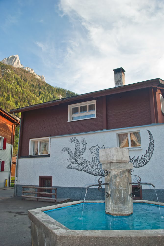 |
| 9 Miles : This is the Village of Vattis and on the wall of this house you can see the kunkel after which the pass is named and seems to be a multi headed hydra like dragon. |
 |
| 10 Miles : The view looking back down the valley at Unterkunkel just up the valley from Vattis. |
 |
| 10 Miles : A small wooden barn sitting in a lovely woodland setting just off the road in Unterkunkel. |
 |
| 10 Miles : A lovely house in Vattis. |
 |
| 10 Miles : The most beautiful scene you could come across - this gorgeous Alpine Chalet in the Village of Vattis is just a photographers dream sitting below the mountains. |
 |
| 12 Miles : Yep - i have reached the snowline and in the North facing sheltered slopes the snow was still lying at the side of the road. |
 |
| 12 Miles : Snow ! |
 |
| 14 Miles : My Garmin shows I had reached an altitude of 4000feet which thought would be peak height ... little did I know I still had another 500feet of ascent ahead. |
 |
| 14 Miles : The view back down the vallley at 4000 feet up in Oberkunkel. |
 |
| 15 Miles : Closing in on the top of the climb nearing 4500 at Oberkunkel |
 |
| 15 Miles : The road was still going up but this is the last bend up ahead of the summit. |
 |
| 16 Miles : 4500feet up and this is the top of the Kunkelpass. |
 |
| 16 Miles : Boy did the road drop quickly the gradient must have been near 20% and the drop over that femur wooden barrier was about 200feet ... sheer. |
 |
| 16 Miles : Suddenly the track went inside the mountain and a dark tunnel lay ahead of me. |
 |
| 16 Miles : The dark & foreboding Tunnel. |
 |
| 16 Miles : Inside the Tunnel I stopped to take some spectacular pictures from the holes they had carved in the side. |
 |
| 16 Miles : Still inside the Tunnel this is the view from one of the view holes carved into the side of the mountain. |
 |
| 16 Miles : Another view from the Tunnel This time a tree clinging to the very edge of a precipice. |
 |
| 21 Miles : Now down the mountain & in the Rhein Valley heading towards Chur. The green fields with a lovely view of a church & a cross with the mountains in the background. |
 |
| 22 Miles : The Rhein just above the hydro electric power station anout 3 miles upstream from Chur. |
Just found the time to look at these Steve - Looks fab
ReplyDeleteHi Steve, great to have this now I am back again and have some time, after struggling with Windows 7 for four hours to fix the updates.. Computers - dont you just love them? Thankfully think it might be sorted through forum; others were having my problem..
ReplyDeleteThanks for dropping by my blog and letting me know of this post after the chat on train ... surely brings back memories of the Swiss miles covered a bit quicker in a Peugeot but perhaps not as well seen?? just love the chocolate box tulip shot, I will be back and let others know too, Shaz in Oz.