Wed, May 30, 2012 - 8.79 mi [Cycling]
8.79 mi in 01:26:17 hours at 6.11 mi/h on Hire Hire. [Cycling] A stinking hot day in Washington DC - I spent the morning on a City Hire bike cycling around the memorials in and around the Washington Monument which was a lot harder than it should have been as they seem to have located the bike docking parks half a mile away from each of the tourist locations - It seems a bit crazy to me !
Pageviews in last month
Wednesday, 30 May 2012
Tuesday, 29 May 2012
Day 8 : Tue, May 29, 2012 - 9.04 mi [Cycling] Washington DC
Tue, May 29, 2012 - 9.04 mi [Cycling]
9.04 mi in 01:25:03 hours at 6.38 mi/h on Trek .. [Cycling] Hired one of those City Bikes for an evening ride around the monuments in DC
9.04 mi in 01:25:03 hours at 6.38 mi/h on Trek .. [Cycling] Hired one of those City Bikes for an evening ride around the monuments in DC
Sunday, 27 May 2012
Day 6 : Sun, May 27, 2012 - 7.78 mi [Cycling] Bowery to City Hall NY via the Brooklyn & Manhattan Bridges
Sun, May 27, 2012 - 7.78 mi [Cycling]
7.78 mi in 00:53:17 hours at 8.76 mi/h on Trek .. [Cycling] Cycled across the two bridges now I have sussed NY and just because they were there !
Twice up to City Hall as I had spotted one of the very few covered cycle racks in NY and decided that will be a good place to leave the bike for 3 days - I went twice as i forgot the lock key first time !!
Saturday, 26 May 2012
Day 5 : Fri, May 25, 2012 - 116.34 mi [Cycling] Orient Point to Brooklyn
Fri, May 25, 2012 - 116.34 mi [Cycling]
116.34 mi in 09:21:24 hours at 12.43 mi/h on Trek .. [Cycling] They said it was impossible to cycle the length of Long Island into NY City.
Well I almost proved them wrong ... only light and my Garmin battery dying stopped me doing it - I did make a valiant attempt but downpours of rain and 2000 traffic lights in the last 20 miles which took 3 hrs to do about 15 scuppered me - the bike is parked up in Brooklyn and I'll ride it into the City tomorrow.
Long Island ride in a nutshell...
1st 40 miles Good cycling
2nd 40 miles HIDEOUS
3rd 40 miles HIDEOUS and snails pace
Day 5 : Fri, May 25, 2012 - 4.16 mi [Cycling] Groton to New London
Fri, May 25, 2012 - 4.16 mi [Cycling]
4.16 mi in 00:20:34 hours at 12.14 mi/h on Trek .. [Cycling] Cycle down to the Ferry Terminal in time to catch the 7am ferry to Long island
4.16 mi in 00:20:34 hours at 12.14 mi/h on Trek .. [Cycling] Cycle down to the Ferry Terminal in time to catch the 7am ferry to Long island
Friday, 25 May 2012
Day 4 : Thurs, May 24, 2012 - 93.81 mi [Cycling] New Bedford to Groton via Providence
Thurs, May 24, 2012 - 93.81 mi [Cycling]
93.81 mi in 07:27:07 hours at 12.59 mi/h on Trek .. [Cycling] Head down ride to get to Groton nearly 100 miles away not starting till noon due to missing an earlier ferry.
Probably the hottest day since I've been here & I got a little bit cooked today - starting to look like a panda again !!
I thought Rhode Island was flat - but I seem to have managed to find 400 feet to climb !!
Day 4 : Thu, May 24, 2012 - 2.02 mi [Cycling] Oak Bluffs
Thu, May 24, 2012 - 2.02 mi [Cycling]
2.02 mi in 00:14:27 hours at 8.39 mi/h on Trek .. [Cycling] Cycle around town taking photographs after breakfast whilst waiting for the 10:50 ferry to New Bedford.
2.02 mi in 00:14:27 hours at 8.39 mi/h on Trek .. [Cycling] Cycle around town taking photographs after breakfast whilst waiting for the 10:50 ferry to New Bedford.
Day 4 : Thu, May 24, 2012 - 6.87 mi [Cycling] Day 4 USA 2012 : Oak Bluffs to Vineyard Haven & Return
Thu, May 24, 2012 - 6.87 mi [Cycling]
6.87 mi in 00:34:05 hours at 12.09 mi/h on Trek .. [Cycling] Up early at 6:45 packed and off to catch the 8am ferry to New Bedford without breaknext ferry was fast which didn't start till 8am.
Got to Vineyard Haven at 7:30 and after 10 mins waiting for the ferry I realised I had left my mobile phones in the Hotel - Needless to say I missed the ferry !
Cycle back to the hotel and I did get that breakfast - Next ferry was 10:50 getting into New Bedford at Noon leaving it tight to cycle 100 miles to Groton and navigate the major City of Providence Rhode Island.
I arrived at my hotel as it got dark - tough ride but timed to perfection
Day 3 : Thu, May 24, 2012 - 34.33 mi Hyannis to Woods Hole
Thu, May 24, 2012 - 34.33 mi [Cycling]
34.33 mi in 02:54:14 hours at 11.82 mi/h on Trek .. [Cycling] Day 3 USA 2012 : Hyannis to Woods Hole
Ferry across from Nantucket to Hyannis and then a ride across to Woods Hole to catch the Ferry to Marthas Vineyard.
It was a tricky ride as there are many creeeks and inlets so its difficult to follow the coast but also inland every road seems to link onto Route 28 which is a really busy & scary road which I avoided as much as possible.
Day 3 : Wed, May 23, 2012 - 20.52 mi [Cycling] Oak Bluffs to Edgartown, Vineyard Haven & Back
Wed, May 23, 2012 - 20.52 mi [Cycling]
20.52 mi in 01:45:55 hours at 11.62 mi/h on Trek .. [Cycling] Cycle along the excellent cycle track to Edgartown which runs between the sea and the Lagoon - very nice cycling.
I went to the Cappy ferry but as it was 6:30 and the ferry finished at 7:30 I didn't go across to Chappaquidick (maybe next time !) cycled back to Vineyard Haven along the cycle path to book tomorrows ferry then back to Oak Bluffs.
Day 3 : Wed, May 23, 2012 - 3.56 mi [Cycling] Vineyard haven to Oak Bluffs
Wed, May 23, 2012 - 3.56 mi [Cycling]
3.56 mi in 00:23:03 hours at 9.27 mi/h on Trek .. [Cycling] Cycle from the Ferry Landing at Vinyard haven across to my very nice Hotel for the night - The Pequot - I would highly recommend it if ever your on MV.
An interesting ride as I had to negotiate a left turn just at the ferry landing on an intersection of 5 roads every one of which had to yield - with about 200 cars & lorries coming off the ferry it was very interesting !
Wednesday, 23 May 2012
Day 3 : Wed, May 23, 2012 - 19.00 mi [Cycling] Nantucket to Siasconset & Polpis Loop
Wed, May 23, 2012 - 19.00 mi [Cycling]
19.00 mi in 01:37:05 hours at 11.74 mi/h on Trek .. [Cycling] Day 3 USA 2012 : Nantucket Siasconset Polpis Loop
An early morning bike ride to seethe island - a slight fret still but dry enough for a scout around and I have dried out the garmin so it is now working again.
Day 3 Narrative
I was up early again and my htoel in Nabtucket was really beautiful tucked away along a quiet side street just of an old fashioned High Street which wouldn't look out of place in the 1930s.
The hotel lady was kind enough to offer to dry all my now drenched cycle clothing and I now had dry gear again - the morning was misty but dry so off I cycled to see the island - I cycled through the quiet cobbled Nantucket Town heading east and soon picked up a perfect cycle track to Siasconsett the most easterly part of the island.
The roud forked and I headed left down a deda straight flat section which ran about 6 or 7 miles to Saisconsett.
I passed some fields with wooded animals - lions & giraffes etc. then I was at the Golf Course so I had to have a quick look :-)
Siasconsett made Nantucket look like a metropolis - I stayed and took a few photos but it was still a bit murky.
The Cycle path now turned North and then west back towards Nantucket. I passed the Lighthouse and another Golf Course which again I stopped to inspect for future reference !
I then passed a museum which had a Lighthouse Lamp outsode and looked really pretty and interesting .. unfortunately it was early, I didn't have time and the season didn't start till tomorrow so it was closed .. bad timing.
I got back to my hotel and said goodbye to my ridiculously small attc room (which was lovely and quaint) and I headed to the dock where I had been told Youngs cycle shop would clean the grime off my bike - it dodn't open till 8 and the ferry was at 8:45 - time for a quick blast I thought ... but they were really busy and couldn't manage so I had a look round the shop and bought myslef a Youngs Nantucket cycle top and matching socks ... very dapper I looked.
And there I was off on the ferry to Hyannis again to start my ride down to Woods Hole ferry to Marthas Vineyard.
Tuesday, 22 May 2012
Day 2 : Tue, May 22, 2012 - 62.46 mi [Cycling] : Provincetown to Hyannis
62.46 mi in 05:31:08 hours at 11.32 mi/h on Trek .. [Cycling] Day 2 USA 2012 : Provincetown to Hyannis
Wet Throughly Wet is my memory of today ...
Well that's after the fantastic cycling this morning through the Beech Forest Trail in the sand dunes at Provincetown - among the best cycling I have ever done and I don't say that lightly ... and Provincetown is fantastic all arty farty and all that but a really chilled place - Its nickname is P'Town and after the last 2 days I think I know why as it was P'ing down !
Day 2 : Narrative
Well today started early again - despite yesterday's exertions I finally tuned in at 11:30 and was back up at 5:45 .. I think my body is still yearning for English time.
I looked out and after spending hours last night drying everything I was disappointed to see yet again .. RAIN !
It was fairly steady but by the time I had cleaned the layers of dirt off my bike from yesterday it was down to a steady drizzle .. so Off I set for Provincetown.
The town was lovely even I was was judging it in the wet - I called into a restaurant for breakfast but was disappointed they didn't do any so it was a coffee and a blueberry muffin for brekkie for me.
I cycled through town and took photos of the very New England collonial style houses which looked pretty in the rain with lots of colourful flowers in the gardens - it must look a picture on a sunny day.
Through town I headed for the absolute headland of Cape Cod which makes barrow in Furness look like a slight detour .. this is a 90 mile dead end on the Cape. I was disappointed the road seemed to go into a huge empty car park from which lots of footpaths went into the dunes - I was about to give up but cycled across the car park and spotted a cycle track :-) and boy what a track - there must be 20 or 30 miles of recently surfaced tarmac tracks through 100 feet sand dunes set in a beech forest - the fauna was beautiful especially in the rain - I took more pictures.
After spending about an hour in the dunes I headed out of town and the weather took a turn for the worst - the forecast said 0.2 inches and steady so it should be much better than yesterday's cloudburst.
Well it just got heavier and heavier and rather than a leisurely cycle back down the Cape it was head down and blast along the Highway 6 again with wagons spraying me in the break down lane I was cycling in.It took what seemed an eternity to clear Truro and reach Wellfleet where the safety of the cycle track awaited and after a few mis starts I eventually guessed the correct turn to pick up the cycle track ... say guessed because it just wasn't signposted at all.
Still raining I was cycling blind now because it had gotten into my Garmin and the screen had locked up and as I type this it still has a problem with the function buttons so god knows if It'll be working tomorrow.
At Brewster I passed a cycle shop so I stopped and bought a map and lots of stuff to keep the rain out which was just starting to ease off. The very helpful shop owner advised me the best way to go as I was going to follow the cycle path all the way till he pointed out there's a 5 mile stretch not built and it currently ends pretty much on a major interstate !
So I navigated off the cycle path at South Brewster and immediately found a convenience store which had a deli - so a quick stop for a chicken curry sandwich on wheat bread and a spicy chicken and rice soup and I was on my way along Tubman Road then Setucket Road down to Yarmouth where i had spotted I could cut the corner along Summer St onto Yarmouth Rd ... well a lovely road branched with a rough road doing right and a sign saying use it at your own risk and the tarmac continued left as I did.... Well after half a mile I was in a very nice reidential cul de sac ! -- Guess which road was mine !
I picked up Yarmouth road which is a feeder to the Interstate 28 and was very busy - coupled with a very very narrow bit of tarmac outside the white line and it was a scary next 2 miles with the edge frequently crumbling and flooded and at one stage I went down a rut about 6 inches deep soaking myself but just retaining control as a wagon went past.
Eventuall I was in town and plain sailing to ferry prot I thought .. i followed the signs then after 5 minues i sensed I was heading out of town - I turned round and sure enough found a sign pointing me backwards - I religiously followed the signs and after an particularly difficult left hand turn on a dual one way street I found mysef at ... The Bus Station !
I went inside and was eventually directed to the ferry terminal and as I type this I am crossing to Nantucket having just eaten a lovely Quahog Chowder. The fret is thick and the swell is starting to make me feel sick - it's also a bit worrying the ferry keeps blasting his horn - doesn't it have radar ???
Day 2 : Photographs
 |
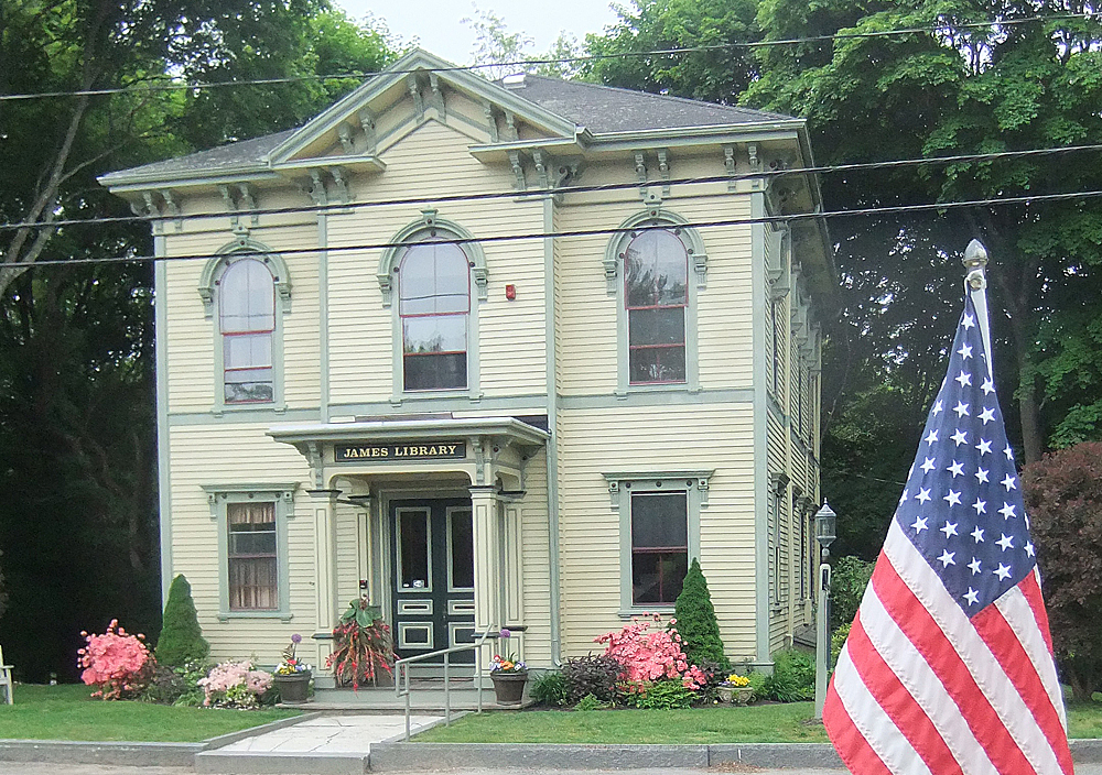
| 0 Miles : My Motel where I had stayed Night 1 after a very late and murky arrival the night before - I washed all the sand off my bike from the night before and was ready for a shorter ride down to Hyannis and the ferry across to Nantucket. |
 |
| 1 Mile : Just along the road from my Motel was a sign showing the Provincetown limits. |
 |
| 2 Miles : On the way into town was one of many pretty wooden houses - this one was surrounded by lilacs. |
 |
| 2 Miles : A view down the main street in Provincetown. |
 |
| 3 Miles : At Wood End this is the view looking straight out onto Cape Cod Bay. |
 |
| 6 Miles : This is Race Point Road a fantastic cycle path created on the Provincetown headland - It as a fantastically smooth cycle track that has been built through Sand Dunes and Beech Forests - after overnight rain the Flora & Fauna was glistening. |
 |
| 6 Miles : Glistening Foliage on Race Point Road |
 |
| 6 Miles : More foliage on Race Point Road amongst the Dunes. |
 |
| 6 Miles : More May Blossom on the Race Point Road. |
 |
| 6 Miles : I wish I knew the names of these flowers |
 |
| 6 Miles : These were pine needle thingies |
 |
| 6 Miles : Even the grasses looked spectacular after the previous days rain. |
 |
| 6 Miles : A cyclist went past whilst I was in the undergrowth - just got him disappearing down the Race Point Road cycle path and soon I was following. |
 |
| 7 Miles : A sign showing the tracks along Race Point Road and the Beech Forest trails |
 |
| 9 Miles : At about 9 Miles I spotted a Turkey like bird scratting around in the undergrowth |
 |
| 9 Miles : More foliage in the Beech Forest |
 |
| 10 Miles : Number 584 |
 |
| 11 Miles : just leaving town on the way to Truro I came across these two visually stunning garages. |
 |
| 33 Miles : The rain had started again so I made an unpleasant ride along state Highway 6 and with my Garmin not exactly waterproof it soon locked up & I was guessing my route Eventually I picked up the cycleway and stopped at a cycle shop to buy a map and polythene bags to wrap my stuff in - No sooner done and the rain stopped ... Typical |
 |
| 48 Miles ; A quick glimpse of the Dennis Pines Golf Club on the way past on Sawtucket Road. |
 |
| 62 Miles : This is Hyannis ferry port from where I would catch the ferry across to Nantucket across a very foggy Nantucket Sound. |
 |
| A close look at the ferry across to Nantucket |
 |
| On Board the ferry ... very little to see |
 |
| My first sight of Nantucket emerging through the mist |
 |
| Inside the Harbour and this is the first view of Nantucket town |
 |
| A walk around town - the mist had cleared slightly so I took advantage of the remaining daylight to look at the town. |
 |
| A reminder of the town's heritage - whaling played a big part in the island's history |
 |
| One of many fine buildings across town |
 |
| Not quite a robin sitting on a reminder of home ... it's almost the Tyne Bridge. |
 |
| A very flower power jeep I spotted in town |
 |
| Starting to get dark - the lights were coming on and I found this sign to help get my bearings |
 |
| Welcome to Nantucket down by the harbour |
Day 1 : Mon, May 21, 2012 - 122.80 mi [Cycling] Boston to Provincetown
Tue, May 22, 2012 - 122.80 mi [Cycling]
122.80 mi in 09:51:24 hours at 12.46 mi/h on Trek .. [Cycling] Day 1 USA Tour 2012 : Boston to Provincetown via Quincy, Pembroke, Plymouth, Sagamore Bridge & The Cape Cod Canal, Barnstable, Dennis & Orleans.
The day started cloudy and deteriorated near Pembroke into a downright Cloud burst with about an inch of rain in 30 minutes which turned the roads into rivers.
I took shelter under a tree but still got soaked - the rain eased but at Wellfleet a nasty fog descended for the last 15 miles of the ride - This is Not what I came to Boston for !!
Day 1 started well - my hotel in Boston was just the job - able to take the bike up to my room and assemble it then leave the bike bag and my hand luggage in the locker room until I got back in 2 weeks.
So the bike was ready and after a 7am breakfast I was ready and away I went on my great American adventure ... who knows what lay ahead of me - my plan was to reach Washington via Cape Cod, Nantucket, mathas Vineyard, Long Island, New York, Philadelphia and Baltimore.
So away i went and the first problem I had was finding a road to cross the Massachusets Turnpike - third attempt I was away and under the Motorway and off along Dorchester Avenue which ran straight south to Quincy and was perfect for cycling.Next I turned left and crossed a bridge which took me out onto the Bay past and old US Navy destroyer which was now a training ship in the harbour.
There was a bit of a breeze up on the Quincy shoreline and after a few miles at Hingham I was glad to move inland and get away from the breeze - my pleasure was soon cut short as I entered the Whitney Woods however as my route which was a perfect minor road was fenced off with do not enter signs. About to turn round I noticed a gap in the fence large enough to get my bike through and obviously people were still using the path - so through i went and soon I was passing an abandoned factory - the road continued and soon I was through another fence and back on track - no harm done.
I cycled on through Pembroke and crossed the Pilgrims Highway into Plymouth where I turned onto the sea front hoping to sea a big monument or something to commemorate the Pilgrim fathers landing - I quickly found a replica of the mayflower in the harbour which in my opinion is a poor copy compared to the one in Brixham in Devon.
I found a seafront chip shop with benches outside so it was perfect to stop and get some food and watch the bike - whilst eating my fish and chips the waitress in the restaurant was keen to know what I was doing and she seemed impressed and keen to get a bike as she said she needed to do something. Another guy passing asked if I was from NZ as I had my Kiwi cycle top on - No I replied I'm from Newcastle in England - funnily enough he was from New Castle is Delaware and had been to Newcastle and soon we were talking football, the Baltic Art gallery and even Colmans Chip shop in South Shields.!
We chatted about Tyneside and Delaware one of the only 2 states with a curved border and apparently the border was drawn by a compass with its centre in New Castle ! ... and the other state with a curved border - well it's obvious - Pennsylvania on the other side of the Delaware border !
I asked where the Plymouth Rock was and he replied it's just a few hundred yards down the road under what looked like a small parthenon - he said "You will be underwhelmed!"
So I finished my chips and off I went to what looked like a small Penshaw Monument under which sure enough on the beach was a small stone with 1620 engraved on it - I was overwhelmingly Underwhemled !!
Next i was off and cycling along the Sandwich Road which runs parallel to the Highway and after 10 miles I was at the Sagamore Bridge - a huge steel arched bridge not unlike the Tyne bridge but without the Towers - It was mizzlly and the arch disappeared into the mist.
Across the bridge & i dropped down to the Cape Cod Canal which has a cycle path the length of it & I couldn't resist cycling completely the wrong way along it for 5 miles to see the sister bridge to the Sagamore - the Bourne Bridge which is Identical.
Back along the Canal & I was heading past Sandwich & Barnstable and looking for another cycle path I had seen which was an old railway line and ran for about 15 miles traffic free.However when I got to Falmouth I saw a shower starting and took cover under a large tree ... and watched as about an inch of rain came down in 10 minutes - the road was now a river !
I waited 30 minutes till it looked possible to ride again and off I went past Brewster and Orleans and still I hadn't found the cycle path - a couple mpore miles and I found it and it was Fantastic - brand new smooth tarmac with absolutely no Traffic . I few past Eastham and was soon on my way to Wellfleet where the path ended and I found myself on the main road - Route 6 which although was a bit busy it did have a wide verge which kept me from the traffic.
A rolling last 30 miles past Truro and as the light dimmed and the mist dropped I homed in on Provincetown - and there was my hotel on the left - on the old coast road - i was stuck on a dual carriageway without any way across - after another half a mile I spotted a possible track across and back tracked a hundred yards the wrong way down the carriageway - then corssed it and founs a small path that lead to the old road and a half mile back down it I was at my hotel a bit wet, tired and soggy - I checked in and promptly found out there was no food nearby and would have to cycle a mile and a half into town p rather than face the misty darkness again I opted for a vending machine and some crisps in the hotel !
Photographs
 |
| 30 Miles : Near Hanover - the cycling is good and I came across a memorial in an old fashioned town |
 |
| 30 Miles : An old Library building near Hanover. |
 |
| 43 Miles : A replica of the Mayflower in Plymouth Bay |
 |
| 43 Miles : A very underwhelming Plymouth Rock |
 |
| 50 Miles : Ooh - It looks just like the Tyne Bridge - If you notice this design has Towers on either side of the arch which the Sagamore Bridge does not have. |
 |
| 56 Miles : My first view of the Sagamore Bridge .. or rather the bottom half of it ! |
 |
| 60 Miles : Now on the other side of the Sagamore and on the Cape cod Canal Cycleway |
 |
| 62 Miles : This is the Bourne bridge form further down the CCC Cycleway. |
 |
| 62 Miles : An arty view of the Bourne Bridge from the Cape Cod canal Shoreline. |
 |
| 64 Miles : Yours truly at the Sagamore Bridge |
 |
| 75 Miles : An absolute cloudburst near Falmouth |
 |
| 99 Miles : I finally found the cyclepath and it was really really good ! |
 |
| 99 Miles : Some of the beautiful fauna along the cyclepath |
Friday, 18 May 2012
Fri, May 18, 2012 - 7.34 mi [Cycling] Newcastle to Jarrow
Fri, May 18, 2012 - 7.34 mi [Cycling]
Max Speed: 26.60
Calories: 425
Elevation: 533
7.34 mi in 00:37:23 hours at 11.78 mi/h on Trek .. [Cycling] Cycle home from the station and into a tough headwind which must have been gusting up to 20mph - and the cold ... is this really May - I'm sure it's February in disguise
Max Speed: 26.60
Calories: 425
Elevation: 533
7.34 mi in 00:37:23 hours at 11.78 mi/h on Trek .. [Cycling] Cycle home from the station and into a tough headwind which must have been gusting up to 20mph - and the cold ... is this really May - I'm sure it's February in disguise
Thursday, 17 May 2012
Thu, May 17, 2012 - 7.44 mi [Cycling] Jarrow to Newastle
Thu, May 17, 2012 - 7.44 mi [Cycling]
Max Speed: 21.90
Calories: 357
Elevation: 336
7.44 mi in 00:35:37 hours at 12.53 mi/h on Trek .. [Cycling] Early morning ride again to Central Station ... talk about Groundhog Day - This time heading in my favourite direction ... North - to Edinburgh - great morning for cycling again and I am certain it will all deteriorate for the weekend again.
Wednesday, 16 May 2012
Wed, May 16, 2012 - 6.49 mi [Cycling] Newcastle to Jarrow
Wed, May 16, 2012 - 6.49 mi [Cycling]
6.49 mi in 00:28:00 hours at 13.91 mi/h on Trek .. [Cycling]
Routine cycle home from Central Station with my weekly Pack of essential items.
6.49 mi in 00:28:00 hours at 13.91 mi/h on Trek .. [Cycling]
Routine cycle home from Central Station with my weekly Pack of essential items.
Tuesday, 15 May 2012
Tue, May 15, 2012 - 6.89 mi [Cycling] Jarrow to Newcastle
| Tue, May 15, 2012 - 6.89 mi [Cycling] | |
| 6.89 mi in 00:35:59 hours at 11.49 mi/h on Trek .. [Cycling] Very early morning ride up to Central Station to catch the 6:25 ... this time heading south to Hereford. | |
Saturday, 12 May 2012
Sat, May 12, 2012 - 25.53 mi [Cycling] Pfaffers to Rheinau & Chur vai Kunkelspass
Sat, May 12, 2012 - 25.53 mi [Cycling]
Max Speed: 35.30 mph
Calories: 3212
Elevation: 2335 ft
25.53 mi in 02:31:11 hours at 10.13 mi/h on Hire Hire. [Cycling] Cycle after work from Pfaffers up and along the valley which lies behind the mountains overlooking the north of Chur - a steady cimb until the last few miles of the climb when the elevation inreased rapidly from about 3000 feet to 4500 feet.
Over the top of the Kunselspass the track dropped away rapidly and was even carved through the rock face in tunnels - it descended intp the Rhine valley at an alaming rate !
Elevation :

Photographs :
 |
| 2 Miles : The beautiful Village of Vadura This is the view looking up the Valley and the ride that lay ahead of me. |
 |
| 3 Miles : Looking across the Valley just after Vadura - the view was fantastic with massive waterfalls and terraced fields. |
 |
| 4 Miles : This is Mapgraggsee which is a dirty green/ blue coloured lake that runs parallel to the rroad for about 3 -4 miles. |
 |
| 6 Miles : I stopped and set up the camera on a post to take my picture cycling along the Valley road which at this point was actually going downhill ! |
 |
| 7 Miles : Fantastic - I was confronted by an avalanche tunnel with stilts on the side - just like you see on the Tour de France in the Pyrenees on the classic climbs like the Tourmalet - now I know this was far less severe but now I was doing my own Haute category Tour climb ! |
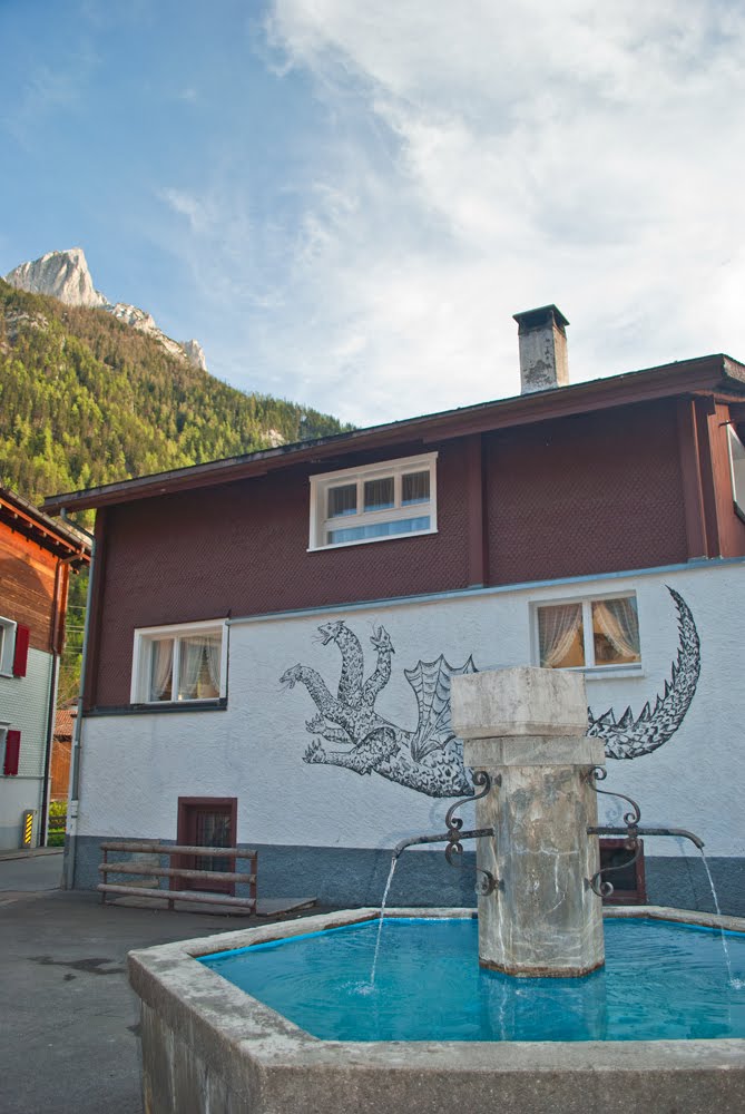 |
| 9 Miles : This is the Village of Vattis and on the wall of this house you can see the kunkel after which the pass is named and seems to be a multi headed hydra like dragon. |
 |
| 10 Miles : The view looking back down the valley at Unterkunkel just up the valley from Vattis. |
 |
| 10 Miles : A small wooden barn sitting in a lovely woodland setting just off the road in Unterkunkel. |
 |
| 10 Miles : A lovely house in Vattis. |
 |
| 10 Miles : The most beautiful scene you could come across - this gorgeous Alpine Chalet in the Village of Vattis is just a photographers dream sitting below the mountains. |
 |
| 12 Miles : Yep - i have reached the snowline and in the North facing sheltered slopes the snow was still lying at the side of the road. |
 |
| 12 Miles : Snow ! |
 |
| 14 Miles : My Garmin shows I had reached an altitude of 4000feet which thought would be peak height ... little did I know I still had another 500feet of ascent ahead. |
 |
| 14 Miles : The view back down the vallley at 4000 feet up in Oberkunkel. |
 |
| 15 Miles : Closing in on the top of the climb nearing 4500 at Oberkunkel |
 |
| 15 Miles : The road was still going up but this is the last bend up ahead of the summit. |
 |
| 16 Miles : 4500feet up and this is the top of the Kunkelpass. |
 |
| 16 Miles : Boy did the road drop quickly the gradient must have been near 20% and the drop over that femur wooden barrier was about 200feet ... sheer. |
 |
| 16 Miles : Suddenly the track went inside the mountain and a dark tunnel lay ahead of me. |
 |
| 16 Miles : The dark & foreboding Tunnel. |
 |
| 16 Miles : Inside the Tunnel I stopped to take some spectacular pictures from the holes they had carved in the side. |
 |
| 16 Miles : Still inside the Tunnel this is the view from one of the view holes carved into the side of the mountain. |
 |
| 16 Miles : Another view from the Tunnel This time a tree clinging to the very edge of a precipice. |
 |
| 21 Miles : Now down the mountain & in the Rhein Valley heading towards Chur. The green fields with a lovely view of a church & a cross with the mountains in the background. |
 |
| 22 Miles : The Rhein just above the hydro electric power station anout 3 miles upstream from Chur. |
Subscribe to:
Comments
(
Atom
)